Core Feature · All Plans
Grade Shots
& Field Data
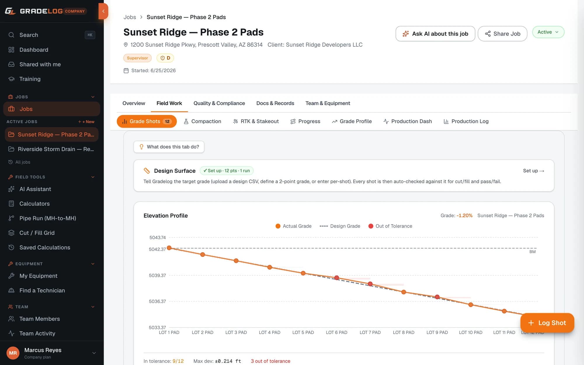
Log elevation shots against design grade with instant pass/fail. GPS-tagged, deviation-flagged, and ready for the inspector — every shot, every job.
What it does
Instant pass/fail on every shot
- Compare as-built elevation vs design grade at the moment of entry
- Configurable tolerance per job — typically ±0.10 ft
- Shots outside tolerance flagged red immediately — no waiting for the office to review
- Re-shoot and resolve out-of-tolerance points in the field
Full GPS/GNSS metadata
- Fix quality, satellite count, HDOP, horizontal accuracy, and correction age captured on every shot
- Station labels and northing/easting coordinates stored
- Shot map view: GPS-located dots color-coded pass/fail on a job map
- Defensible record if tolerances are ever disputed
Import from any instrument
- Topcon MAGNET Field CSV
- Trimble Access CSV
- Leica Captivate CSV
- Spectra Precision CSV
- Generic CSV with column mapping
Shot types and attachments
- Grade shot, invert elevation, compaction reference, benchmark
- Photo attachment per shot
- Description and lift number fields
- Surface type tracking
How it works
01
Set up your job
Create a job in Gradelog, enter design elevations from your grading plan, and set your benchmark reference and tolerance.
02
Log shots in the field
Enter each as-built elevation as your crew takes it. Gradelog instantly calculates deviation from design and flags pass or fail.
03
Review flagged deviations
After a run of shots, review the deviation summary. Out-of-tolerance shots are highlighted. Photograph and note corrective action.
04
Generate the shot log report
Export as a PDF — all shot locations, design elevations, as-built elevations, deviations, and GPS metadata. Ready to submit.
Who uses this
Grading contractors
Pad elevations, swale grades, detention pond bottom — every shot logged and proven before the inspector shows up.
Sewer & utility contractors
Invert elevations, manhole-to-manhole grades, and depth-of-cover shots — all captured with GNSS metadata for city acceptance.
Solar EPC contractors
Pile cutoff elevations compared against EPC design — pass/fail on every pile, packaged into an as-driven report for sign-off.
Common questions
What GPS metadata does Gradelog capture on grade shots?
Gradelog captures GNSS fix quality, satellite count, HDOP (horizontal dilution of precision), horizontal accuracy in meters, and correction age in seconds — the same metadata a licensed surveyor documents. This protects you when tolerances are disputed.
Which equipment CSV formats does Gradelog import?
Gradelog imports CSV from Topcon MAGNET Field, Trimble Access, Leica Captivate, Spectra Precision data collectors, and any generic CSV with column mapping. Bring your existing data in without re-keying it.
What tolerance is used for pass/fail?
Tolerance is configurable per job. Typical earthwork grading uses ±0.10 ft. Pad certification and solar pile work often uses ±0.05 ft. Any shot outside your set tolerance is immediately flagged red.
Can I attach photos to individual grade shots?
Yes. Each shot can have a photo attached — useful for documenting out-of-tolerance conditions, structure benchmarks, or site conditions at that point. Photos are included in the as-built report.
From our sister store
Need the hardware too?
Express Tools carries the grade lasers, receivers, and total stations behind every shot you log — Topcon, Trimble, Leica, and Spectra.
Grade verification across every sector
Whether it's solar pile cutoffs, airport grade, DOT road subgrade, or pad certs — grade shots are the core of every earthwork job.
Start logging
shots today.
Free plan available. Cancel anytime.
Get StartedFree plan availableNo card to startCancel anytime